Reference Material for the Spencer’s Island Marine Environment
By Kerr Canning. Prepared 2008 Reposted with updates 2021.
Introduction
The Coastal Environment at Spencer’s Island consists of tidal flats, a coastal barrier, salt marshes, and a “raised outwash terrace” formed as a result of a complex process that took place when the ice melted at the end of the last ice age. In order to deal with the environmental and ecological components of the Spencer’s Island coast one must become aware of the diversity, complexity, and importance of the watershed ecosystems located on the two arms of the Upper Bay of Fundy. Such an awareness can be gained by examining the on line document “Ecosystem Overview Report for the Minas Basin, Nova Scotia”. This report, abbreviated EOR, was prepared in 2007 for Fisheries and Oceans Canada by M.Parker, M. Westhead and A. Service.
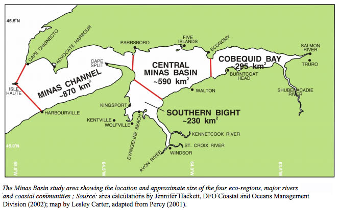
Fig 1. From Ecosystem Overview Report for the Minas Basin by M. Parker et al., 2007. Fisheries and Oceans Canada, Fig 1.2, page 4. Click on image for the Report
The community of Spencer’s Island is on the north shore of the Minas Channel. The map above shows that Spencer’s Island ecosystems, such its salt marsh and tidal flats, are adjacent to the Minas Basin (the major EOR study area). Differences must exist between the Minas Channel and the Minas Basin eco-regions. I would expect, however, that these two tidal regions have enough in common for the EOR to be useful at Spencer’s Island. An examination of the EOR table of contents will, for example, provide a list of the topics that that one must consider in a study of any Upper Bay of Fundy ecosystem. These topics range from geology and sedimentology to the biological systems that exist in the tidal flats, salt marshes and waters of the Minas Basin.
The EOR is a long report (179 hard copy pages and 199 PDF pages) containing a wealth of information. I suggest that you first read “13.6 Coastal Habitats”, a four page section starting at page 144 on the PDF version. Then consult the table of contents and read portions of EOR that are of interest.
Note that the EOR defines the Minas Basin to be all of the regions shown on the above map. As well, the EOR does not use the term Upper Bay of Fundy for the head of the Bay. The term Inner Bay of Fundy is used and the Inner Bay of Fundy “is divided into Chignecto Bay to the North and the Minas Basin to the south.” The remainder of the Bay of Fundy is called the Outer Bay. See the EOR section “1.2 Boundaries of Study Area” on PDF page 22.
The Gulf of Maine and Links to Additional Source Material
Spencer’s Island, located on the Minas Channel-Minas Basin arm of the Upper Bay of Fundy, is part of a large costal environment called the Gulf of Maine. This semi-enclosed and high tidal range sea is one of the world’s most biologically productive ecosystems. Several government and non-government institutions in both Canada and the United States are excellent source of online information on this important coastal region. Several web sites are given below.

From the cover page of Ocean Zoning for the Gulf of Maine: A Background Paper by Fara Courtney & Jack Wiggin 2003.
Gulf of Maine Council on the Marine Environment
“The Gulf of Maine Council on the Marine Environment, created in 1989 by the governments of Maine, Massachusetts, New Brunswick, New Hampshire and Nova Scotia, works to foster environmental health and community well-being throughout the Gulf watershed.” Many publications and other information are provided on this website.
Bay of Fundy Ecosystem Partnership
“The Bay of Fundy Ecosystem Partnership is a “Virtual Institute” open to both individuals and groups who are interested in the well being of the Bay of Fundy. It is our goal to promote the integrity, vitality, biodiversity and productivity of the Bay of Fundy Ecosystem, and the social well-being and economic sustainability of its coastal communities. We strive to facilitate communication and co-operation among individuals and organizations interested in understanding, sustainably using and conserving the resources, habitats and ecological processes of the Bay of Fundy.”
OERA
At OERA (the Offshore Energy Research Association), we’re navigators and collaborators helping Nova Scotia move toward a more sustainable energy future by providing the unbiased information and insight needed to plan a path forward.