Drafting, (Oct 8, 2023)
Long Title:
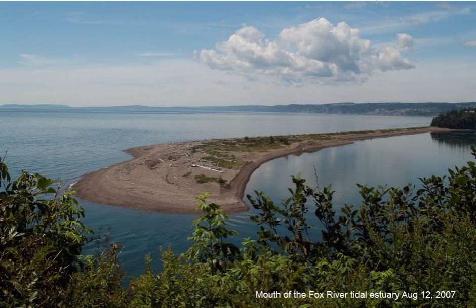
Evolution of a long shore gravel bar (tombola) located at Edgetts Beach, Cumberland County, Nova Scotia (2011-2023)
Author: Ken Adams
Introduction

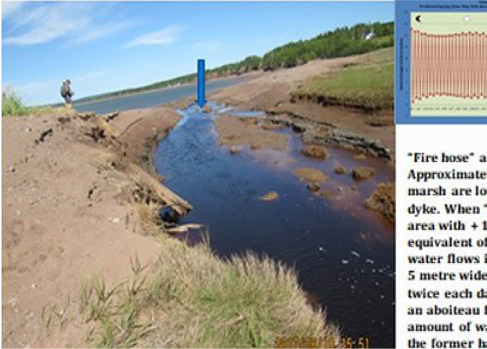
Edgetts beach area. Arrow point to location if badly storm damaged aboiteau.
Click on images on this page for larger versions
Over the past 13 years tidal erosion has had a visible impact on a longshore gravel bar, saltmarsh, dyke and road bed located at Edgetts Beach, West Apple River.
In searching for an explanation for these changes a literature search was initiated and a number of researchers were contacted at the Bedford Institute of Oceanography, the Center of Geographic Studies and the Department of Mines and Energy.
The changes appeared to be related to a peak in the tidal range, associated with an 18.6 year lunar cycle, “Spring” tides and possible storm surges.
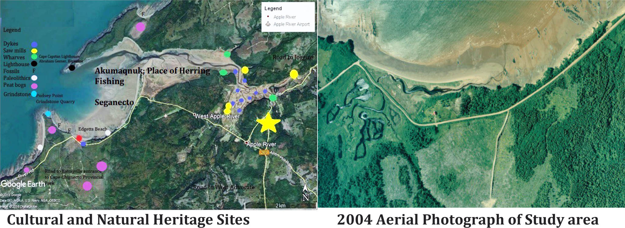
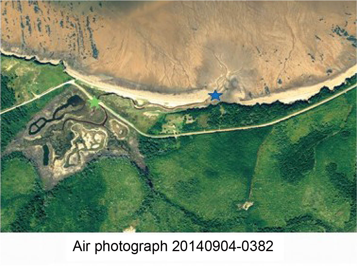
Location of the study area
The longshore gravel bar at Edgetts Beach is located on the southwest side of the Apple River Harbour, Cumberland County, Nova Scotia. It is situated on the seaward side of a dyke and a section of the dirt road between Apple River and West Advocate that provides access to the Eatonville day use area of Cape Chignecto Provincial Park.
Historical Background
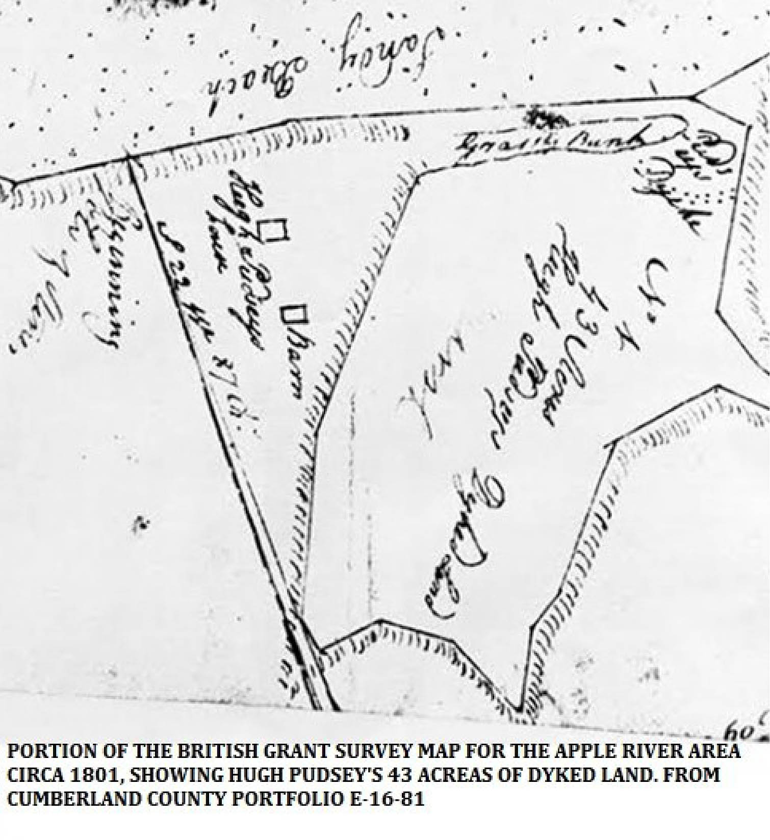
Prior to the Acadian settlement of the Apple River area, in the early 1700’s (?), a low lying intertidal salt marsh and peat bog would have been present behind the longshore gravel bar. Hugh Pudsey’s Grant, as shown on the circa 1801 British survey map for Apple River, included 43 acres of “Dyked Land (marsh)”, with a short dyke located at the southeast end of a “Gravel Bank”. This area was used as a hay marsh, beginning in the early 1700’s, by Acadians, and subsequently by Planters/Loyalist settlers and their descendants, possibly until the late 1860’s. Wide spread destruction of many of the dyke systems along the Bay occurred during the Saxby Gale, and a newer structure and road bed appear on Hugh Fletcher’s GSC Map. The portion of the hay marsh on the seaward side of the new dyke reverted to intertidal saltmarsh. The hay marsh on the inland side of the “modern dyke continued to be used until the 1950’s (aboiteau sluice replaced and a metal framed flapper gate was installed around this time?). In the 1970’s a Ducks Unlimited impoundment was created on the west side of the road.
Highlights of observations

Click on image for larger version
2011-2012: Periodic flooding of the road to the Eatonville entrance of Cape Chignecto Provincial Park due to the deterioration of the aboiteau located in the dyke. In early 2011 sediment from the foreshore was driven up and over the top of the gravel bar blocking portions of the stream channel located behind it. The vegetation on top of the bar gradually eroded away.

Click on image for larger version
2013: The section of the dyke containing the aboiteau sluice and flapper gate was breached by a series of extreme “Spring” tides and possible storm surges. A bridge was built over the gap in the road bed. The lack of an aboiteau flapper/gate allowed millions of litres of water to freely flow through the gap in the dyke (first time in 250 plus years?).
Click on image for larger version
2014- 2016: As the vertical range in the tides continued to increase further reduction in the height of the central portion of the bar, directly in front of the gap in the dyke, and downstream was noted. Very little vegetation was present on the top of the bar and sand and gravel from the foreshore was migrating inland into the stream bed between the remnants. The mouth of the stream running behind the bar has retreated slightly westward from its 2012 location.
Click on image for larger version
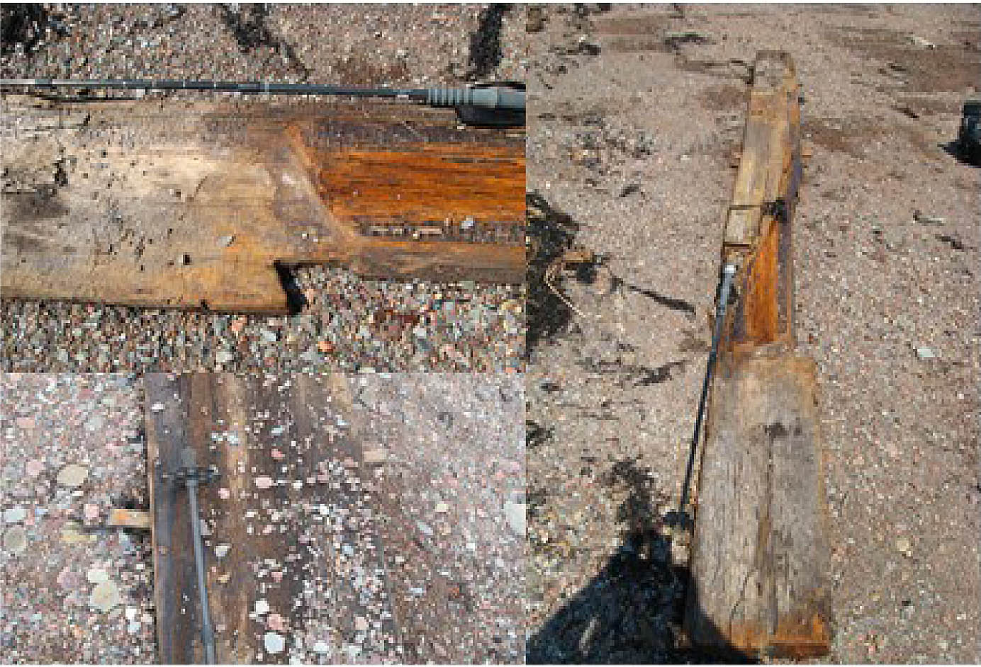
July 25, 2015: The side board from an aboiteau sluice was noted on top of the north end of the longshore gravel bar. The location of the flapper was inferred/indicated y the abraded inner face adjacent to a “notch”. Square pegs were used to hold the top and bottom slab/boards to the sides of the sluice. Parallel tooth marks suggested that an” up and down” saw blade had been used to manufacture the side board (pre-dating introduction of circular saw blade in the mid 1800’s?).
Click on image for larger version
2017: In late May a new stream channel was cut through the bar, directly downstream from the opening in the dyke, revealing a 3 to 4 metre cross section through the bar and the older marine/intertidal sediments lying below it. A man made brush structure, the base of a dyke, was exposed in the bottom of the new stream bed. A second man made structure was noted + 100 metres to the southeast. The breach may have been associated with the “Spring” following the New Moon tides on May 25th and a possible storm surge.
Click on image for larger version
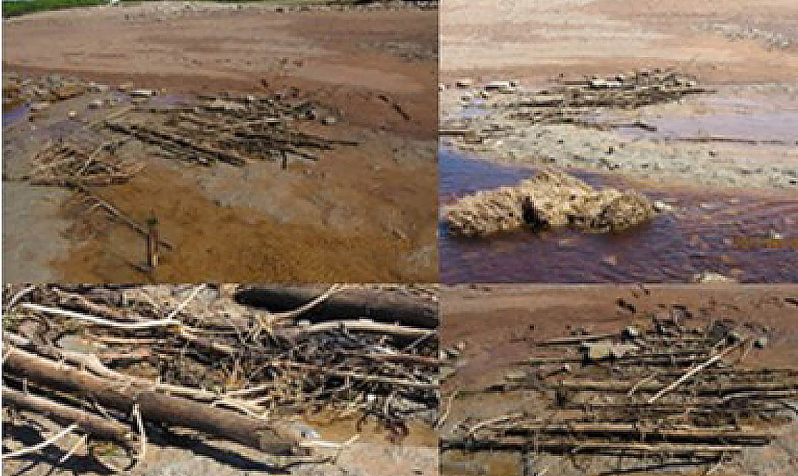
The brush structure exposed in the bottom of the new stream bed appeared to have been situated directly under the former location of the longshore gravel bar. Layers of coniferous tree tops with attached vegetation (cut with an axe blade) and clay sods with laminations of black terrestrial organic, had been laid down on top of the uppermost blue-grey marine clay containing clam shells, terrestrial debris and gravel. The top of at least one vertical pole was noted, driven down into the underlying clay.

Click on image for larger version
On the south of the new stream bed sediment from the foreshore continued to be driven inland into the former stream channel and over the surface of the salt marsh towards the larger pond adjacent to the “modern” dyke. When the seaward edges of the salt marsh mats re- appeared they were rapidly eroded, and a larger area of the blue grey clay layer was exposed. Layers of hay marsh and salt marsh sediments were deposited on top of this structure after it ceased to function. In the central portion of the image further erosion exposed a 6 meter long sluice.
On July 5th, 2017 a lumbar vertebrae (Bovine?) was noted downstream for the eastern margins of the brush works, imbedded in the blue-grey clay lithology. Several impressions, which may be footprints, were present in the clay surface (resembled Oxen or Caribou hoof prints).

Click on image for larger version
A satellite image, taken on October 12, 2017, shows the breach in the longshore gravel bar, and the partial infilling of the former stream bed southeast of the brush structure. Gravel and sand on both sides of the breach have advanced landwards over the salt marsh surface.

Click on image for larger version
The tops of two vertical posts were noted 50 meters southeast of the brush structure in July. As the material from the longshore bar migrated landwards more of the upper portions were exposed, along with a series of poles aligned perpendicular to the shoreline. This arrangement resembles the posts used to support the Mackerel and Shad nets at Minudie (diorama at King Seaman Museum. (By 2023 plus 1.3 meters of each pole had been exposed). Erosion of the hay marsh and saltmarsh mats on top of the brush structure continued to expose more layers of poles and sods on the southwest side of the new stream channel. Two rows of poles separated by a core of clay sods made up the seaward and landward facing sections of the dyke. Linear groove/depressions in the blue-grey clay indicated where some of the horizontal poles had been washed away/