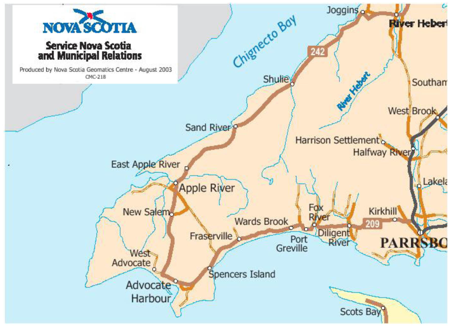
Fig.1: The Western End of Cumberland Co. on the Upper Bay of Fundy.
Click on images for larger versions
Several examples illustrate the value of the GSC Maps as tools for locating sites of human activity that are no longer in existence. The examples deal with sites found in the western portion of Cumberland Co. (Fig.1).
Example One: Timber Driving Dams and Fresh Water Meadows
The 1904 Faribault-Fletcher maps have a special appeal to researchers who were teenagers in the 1950,s and who, during that time, spent many hours becoming acquainted with the forests in rural Nova Scotia. These maps bring to memory the mysterious decaying dams that were located on many of the streams and rivers flowing through the woods. The maps also remind such a researcher of fishing in what remained of large meadows where early settlers once grew hay. Faribault and Fletcher have recorded the locations of these almost forgotten sites of late nineteenth and early twentieth century activity. The dams, known as timber driving dams, were part of the lumbering industry and the meadows attracted settlers because natural grasslands provided hay that was often in short supply. Locations of timber driving dams, millsites, and meadows recorded on the GSC maps represent possible archeological sites. Because these sites are on rivers and streams they are also part of the water power/ water resources topic. A waterpower publication that may be relevant to archeology was published ca 1923 by what was then the Water Resources Branch of the Department of the Interior. The publication is a report titled the History of Water Power Legislation and Administration in Nova Scotia. This report and the list of waterpower legislation provided in an appendix warrant investigation by researchers who have an interest in finding archaeological sites located along streams and rivers. [6]
Two former fresh water meadows, Jenks Meadow and Tipping Meadow, are marked on Fig.2. A road from Harrison Settlement to Sand River (Fig.1) passes close to each meadow. Families no longer live on or harvest hay on these meadows and nothing remains of the former lumbering village of Sand River.

Fig. 2. Fig.2: The Old Road to Sand River. Taken from the 1905 Faribault-Fletcher Southhampton Sheet No.82. Reproduced with the permission of the Minister of Public Works and Government Services Canada, 2005 and Courtesy of Natural Resources Canada,Geological Survey of Canada.
Driving dams and lumber camps are shown on both Fig.2 and Fig.3. Little remains today of these once numerous sites of labour intensive activity!

Fig. 3. Timber Driving Dams and Lumber Camps. Taken from the 1904 Faribault-Fletcher Apple River Sheet No.100 and 101. Reproduced with the permission of the Minister of Public Works and Government Services Canada, 2005 and Courtesy of Natural Resources Canada,Geological Survey of Canada.
Example Two: Grind Stone Quarry at Apple River
Small communities often have stories about industries, such as small mines, shipyards, and quarries that existed in the settlement sometime in the remote past. Apple River, for example, is reported to have had a sandstone quarry that operated somewhere at the edge of the harbour. The 1904 Faribault-Fletcher multicoloured map titled Apple River Sheet No.100 & 101 provided the author with the first verification for the existence of an Apple River quarry. This map shows a grindstone quarry as well as a number of buildings located at entrance to the harbour (Fig.4).
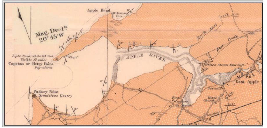
Fig. 4. Apple River Harbour. Taken from the 1904 Faribault-Fletcher Apple River Sheet No.100 & 101. Reproduced with the permission of the Minister of Public Works and Government Services Canada, 2005 and Courtesy of Natural Resources Canada,Geological Survey of Canada.
Example Three: Establishing the Physical Location of The Village of Eatonville
For several decades of late nineteenth and early twentieth century a small lumbering and shipbuilding community existed within the boundary of what is now Cape Chignecto Provincial Park in Cumberland Co., Nova Scotia. The community consisted of two sections: a harbour, with an entrance uniquely defined by rock formations called the Three Sisters, and a village one or two miles inland. The exact location of the village as well as its physical layout have largely passed from living memory. This is unfortunate because the location of archaeological sites that form the remains of this once thriving community are now being sought: Eatonville will soon become Cape Chignecto Park’s second entrance.
As can be seen in Fig.5, the 1904 Faribault-Fletcher Apple River Sheet clearly shows the physical layout of the two components that formed the lumbering and shipbuilding community of Eatonville; nothing much remains of this community today.
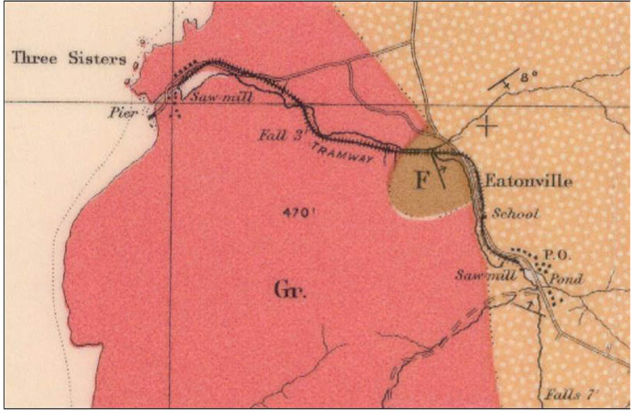
Fig. 5: Eatonville. Taken from the 1904 Faribault-Fletcher Apple River Sheet No.100 & 101. Reproduced with the permission of the Minister of Public Works and Government Services Canada, 2005 and Courtesy of Natural Resources Canada,Geological Survey of Canada.
Notes
6. Library and Archives Canada, Report # 684, A History of Water Power Legislation and Administration in Nova Scotia, Department of the Interior, Water Resources Branch, RG 89, Volume 528 .