Fig.1: Timbers from a water mill and the shaft section of the mill’s waterwheel emerge from an eroding river bank. Scouring by cake ice during the winter of 2010-2011 and strong currents in the spring of 2011 flushed the shaft from the bank and exposed the timbers.
Introduction
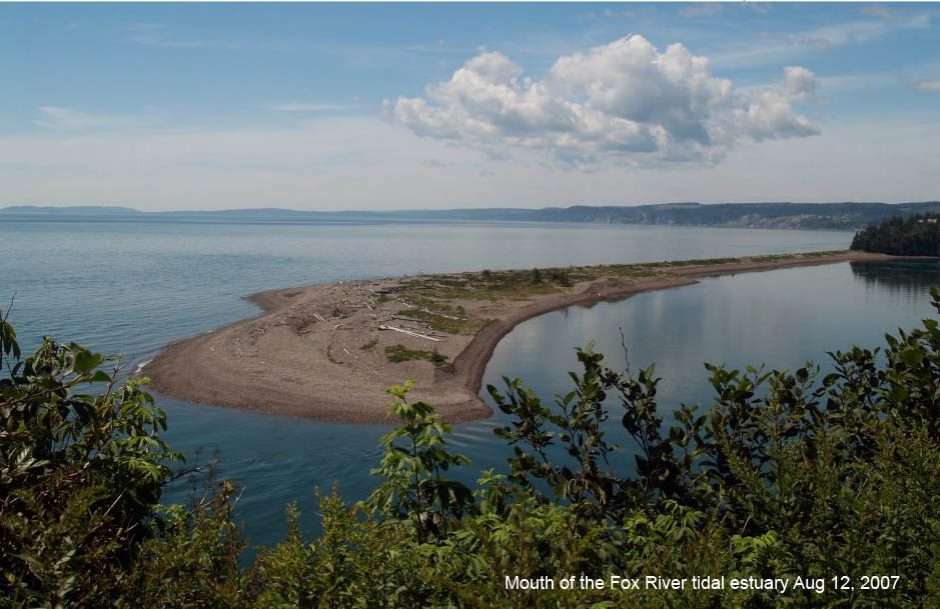
This webpage and subsections provide the ongoing research and interpretation of a timber framed structure, a wooden shaft and a mill pond that were part of an early, unique water mill that is slowly emerging from an eroding river bank on a bend in a tidal river that flows through a salt marsh at Apple River.* The river bank is located on the South Branch of the Apple River and the salt marsh is located on the upper reaches of a Bay of Fundy estuary located at Apple River on the tip of the Chignecto Peninsula, a triangular region that forms the western end of Cumberland County, Nova Scotia, where the tides are among the highest in the world (see Fig.2). When the mill was abandoned in the 1870’s, a large portion of its wooden foundation was preserved as a result of sea level rise caused by coastal subsidence (Grant, D. R., 1970) of the Bay of Fundy. The resulting increase in tidal amplitude delivered silt to the lower section of the mill and a blanket of salt marsh formed over the bottom portion of the mill’s structure. The wood under this covering was oxygen starved and consequently, did not decay. The research is ongoing as annually, more mill components are flushed from the river bank as a result of scouring by winter cake ice and by spring flooding.
____________________________
*Some of the materials in this section were published in a paper, A Mill of the salt marsh of Canada’s Bay of Fundy, by Kerr Canning in International Molinology 2015, Vol 91, pp 45-54.
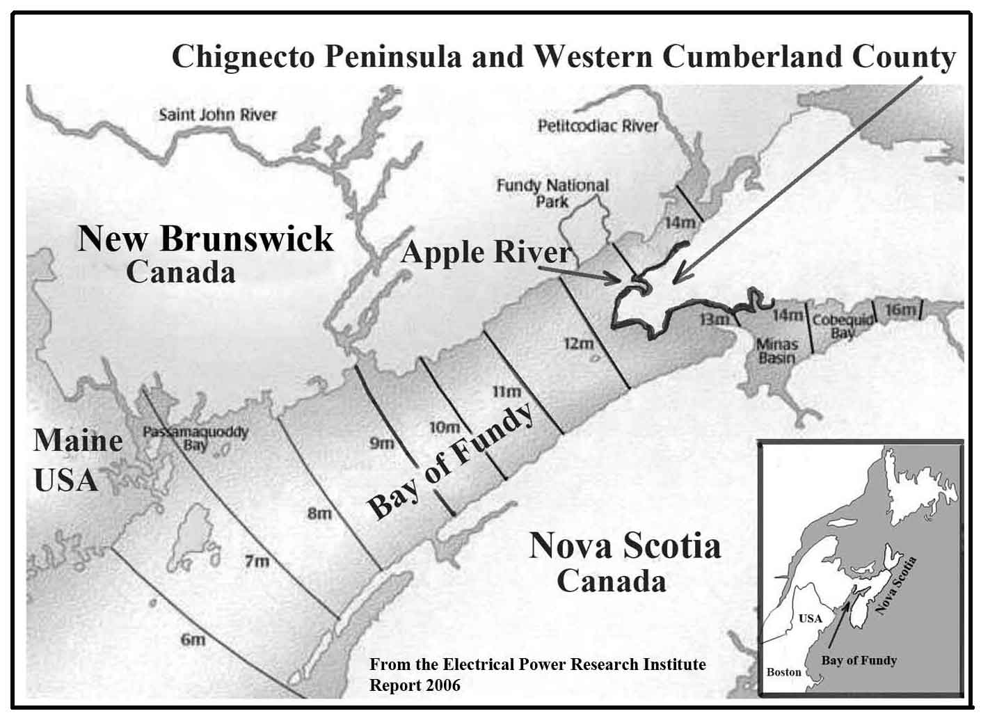
Fig.2: The location of the Apple River mill and the tidal range in the Bay of Fundy.
Field Work and the Discovery of an Early Water Powered Mill
Two rivers, the East Branch and the West Branch, flow into the Apple River Estuary (see Fig.3). Salt marshes are found on both branches and since 2004, the author has been researching the history of the dykes (sea walls) and aboiteaux (tide gates) found on these tidal wetlands. The field work required the research to be conducted during the summer months, from April to late September. Part of this field work involved observing the banks along both branches. In 2007, several large, timber framed structures were observed to be slowly emerging from an eroding bank located on a bend in the South Branch (Fig.1). The uncovered portions of these objects appeared to be the remains of crib work used in wharf construction. Such remains are common along the coastal regions of Nova Scotia.

Fig.3: The Apple River Estuary. Field work discovered mill sites in the rectangular area marked on the South Branch of the Apple River.
A possible identification of the timber framed structure occurred on a visit to the site in early May, 2011. During the previous winter, as a result of scouring by cake ice, snow and spring flooding, a large section of the river bank was flushed away and what appears to be the shaft section of a campus arm waterwheel was exposed (see Fig.4 and 5). One end of the shaft was missing and for some unknown reasons, the compass arms had been sawed off and a pulley had been attached to the other end of the shaft. With that discovery, evidence was provided that the river bend must have been the site of a water powered mill at one point in time. As a result of this discovery, a search for historical documents dealing with mills on the South Branch of the Apple River was initiated and this search must cover two archeological sites, marked “Upstream Site” and “Downstream Site” on Fig.4.

Fig.4: Two Archeological Sites exposed on the eroding river bank: View looking up river.

Fig 5. The downstream archeological site showing a mill shaft and a water pipe or sluice. Scouring by cake ice and spring flooding during the winter of 2010-2011 flushed both objects from the eroding riverbank.
Initial Research for the two Archeological Sites on the South Branch of the Apple River: the Mill Owners, Folklore and an 1881 Newspaper Article
The search for material on the mill emerging from the bank of the West Branch of the Apple River started with a story and the reprint of an 1881 newspaper article. The folklore story claimed that a long time ago a boiler in a nearby steam driven sawmill exploded and a piece of the boiler landed in the dooryard of the house shown in Fig.6. The mill was believed to have been located somewhere at the bottom of the hill that dips sharply downward at the back of this house and ends abruptly on a salt marsh, leaving no suitable upland for a mill between the foot of the hill and the salt marsh. The story always assumed that a steam mill would not be placed on a salt marsh. It is interesting that the upstream archeological site discovered on May 14, 2011 is on the salt marsh below the house shown in Fig.6.
Fig. 6. A folklore story claimed that a long time ago a boiler exploded in a nearby steam driven sawmill and a piece of the boiler landed in the dooryard of the house at the top of the hill.
The newspaper article (Amherst Daily News), in the 29th of September 1881 issue of the Chignecto Post, describes the explosion of a boiler at a steam mill located near a scow. The article reads:
Mr. Isaac Spicer’s steam mill at Apple River, Cumberland County, Nova Scotia blew up on Sept. 9, 1881. The ends blew out of the boiler and the body of it was thrown vertically over one hundred and fifty feet, and nearly as far horizontally. Fortunately the men were in another part of the mill from that containing the boiler and were eating dinner, and nobody was hurt. Mr. Spicer, himself was sitting in a scow at the time near the mill, and hearing the explosion, had the presence of mind to throw himself into the water, just in time to escape a piece of the shattered boiler, which struck and smashed the scow where he had been sitting.
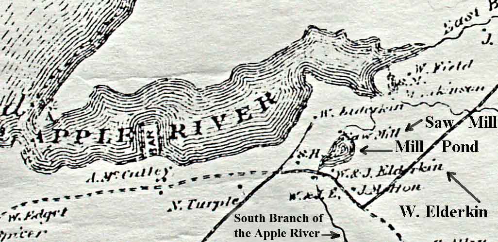
Fig 7. A section of an Ambrose F. Church Map showing a saw mill on the South Branch of the Apple River. Note the names W. & J. Elderkin by the sketch of the mill pond
A possible location for “Mr. Isaac Spicer’s steam mill is strongly suggested by a map published by the Ambrose F. Church Company (Fig. 7). This map was part of series of maps providing information on built structures on Nova Scotia’s landscape for the years 1865 to 1888. These maps (Nova Scotia Archives) show the locations of structures such as buildings, mills and the names of people who live adjacent to these structures.
The Mill Owners
The names W. & J. Elderkin that appear by the sketch of the mill pond in Fig.7 are second generation members of one of Apple River’s founding families. These families arrived from New England and occupied land grants issued in Apple River at the end of the American Revolution. Members of the Elderkin family were millwrights and by the early 1800’s they had acquired a large section of the valley, including the salt marshes, through which the South Branch of the Apple River flows. Three of the second generation Elderkins, William Rufus, Jeptha and Albert C. Elderkin were involved both together and individually in several business activities. For example, the 1855 registration of the two-masted schooner Selma(Library and Archives Canada) in the Shipping Register for the Port of Parrsboro, Nova Scotia states that the subscribing owners are William R. Elderkin and his brother Jeptha and that they are trading together under the firm of William R. and Jeptha Elderkin. As well, the industrial section of the 1871 Canada census contains an entry for the Apple River region stating that William R. Elderkin owned a water powered sawmill operated by two men and a boy for three months of the year.
The name Isaac Spicer is perhaps the most important item in the newspaper article from the1881 issue of the Chignecto Post. A search for this name in the Cumberland County Registry of Deeds (Cumberland County Registry of deeds,) produced a document with new information. The document was an agreement between an Isaac Spicer of Apple River and Albert C. Elderkin of Athol, Cumberland County. The agreement, dated May 1, 1878, gave “Isaac Spicer the privilege of putting up a steam mill on Albert C. Elderkin’s marsh near William Elderkin’s mill for a term of fifteen years. Albert C. Elderkin also agreed to allow Isaac Spicer the use of his half of the mill pond, known as the W. R. Elderkin mill pond, to hold and float logs. In return Isaac Spicer was required to pay Albert C. Elderkin four dollars yearly rent to be paid on May 1st each year.
A search for the name William Elderkin in the Parrsborough Township Registry of Deeds (Parrsborough Township Registry of Deeds, 1888) located a deed, dated March 20, 1888, stating that William R. Elderkin of Apple River (and Hannah, his wife) gave their daughter Emma Spicer, wife of Isaac Spicer of Apple River, a lot of land at Apple River on which Emma Spicer’s house and other buildings stand. The deed stated that one boundary line commenced at land laid off for a grave yard and passed in a south easterly direction to the mill pond. The land laid off for a grave yard is at the top of the same hill as the house shown in Fig.6 and is located a short distance to the left of this house. In 1884 the site for the Methodist Church adjacent to the grave yard was deeded to the Trusties Methodist Church of Canada by William R Elderkin and Albert C. Elderkin.
By 1886, Isaac Spicer was indebted to several creditors and was not able to pay his debts. To liquidate his debts, Isaac Spicer, in a deed of trust dated May 13, 1886, agreed to assign all of his estate and effects to William R. Elderkin. The effects included “ a lot of piling and spruce saw logs in the pond and in the river near the saw mill of the said Isaac Spicer at Apple River”. Presumably, William R. Elderkin paid the creditors by selling such assets as Isaac Spicer’s mill. If so, the mill may have ceased operating and the machinery removed. In 1894 William R. Elderkin sold two acres of land on the hill above the mill pond to John Leslie. The deed description states that the property boundary started “at a stake set on the bank near the old Mill Pond..” The phrase “old Mill Pond” might indicate that the steam mill was no longer functioning.
Also, the mill is not marked on the 1904 Faribault-Fletcher Apple River Sheet No.100 and 101 (Faribault-Fletcher, 1904).This Geological Survey of Canada map shows several the mills operating in Apple River. Certainly Isaac Spicer was no longer doing business in Nova Scotia. He moved to Bellingham, Massachusetts, where he died in 1906.
The above mentioned references suggest that the downstream archeological site contains the remains of William R. Elderkin’s water powered sawmill, a mill constructed on a salt marsh sometime before 1871. As well, the above mentioned references would suggest that the upstream archeological site contains the remains of Isaac Spicer’s steam powered sawmill, a mill also constructed on a salt marsh sometime after 1871.
The mill pond for the steam mill was created by modifying a section of William R. Elderkin’s mill pond. This will be discussed in the next section which presents the observations and research for the mill pond.
The Mill Pond on a Salt Marsh
The Mill Pond Walls
In addition to the two mill sites found during the May 2007 field work, two dyke arms on the same salt marsh were also discovered. These arms are shown in Fig.8 and Fig.9, These arms are clearly shown in the rectangle marked on the aerial photograph in Fig.3. An enlargement of this rectangle is given in Fig.10.

Fig.8: One of the dyke arms on the salt marsh. It will be referred to as N30E.
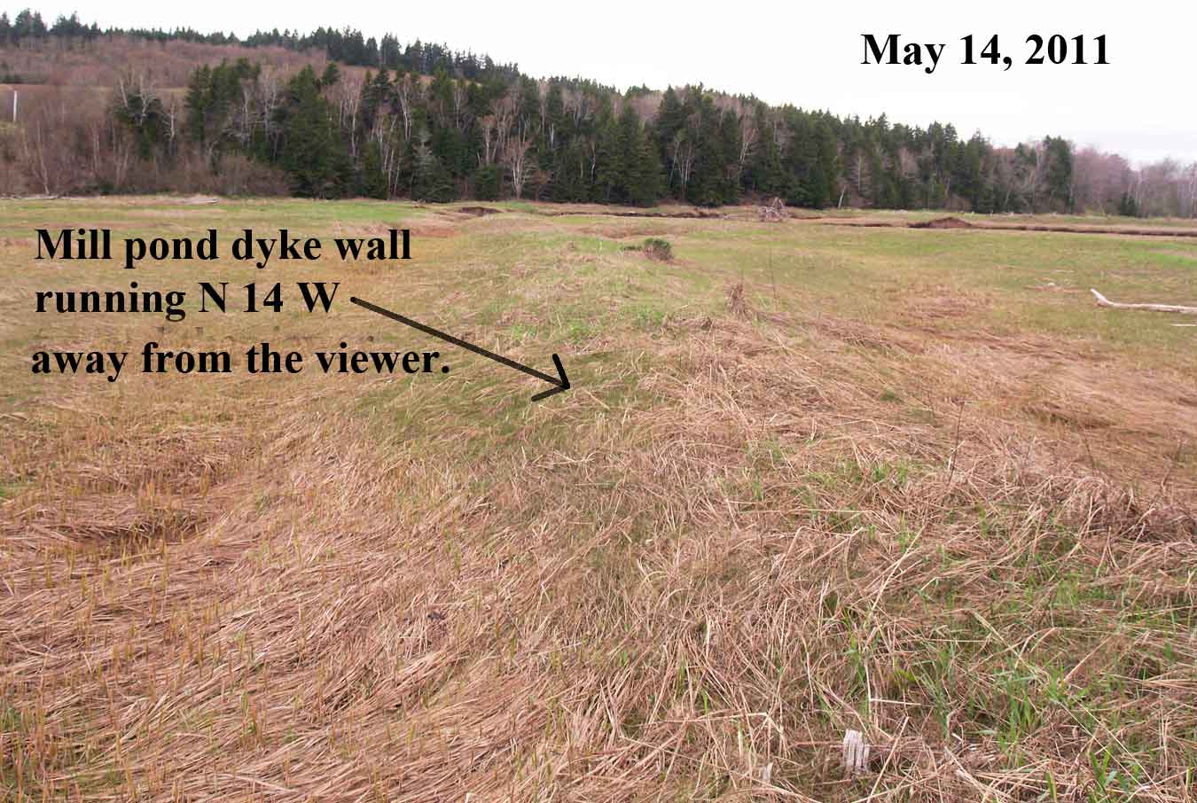
Fig.9: The second dyke arm on the salt marsh. It will be referred to as N14W

Fig.10: The two converging dyke arms on the salt marsh.
The mill pond, shown in Fig.10 is triangular in shape. The two dyke walls that converge to form an Apex at the mill sites. The broad bottom of the triangle is actually a ridge of upland that is significantly higher than the salt marsh and therefore forms a natural containment wall for the mill pond as illustrated by the high and low tide in Fig.11.
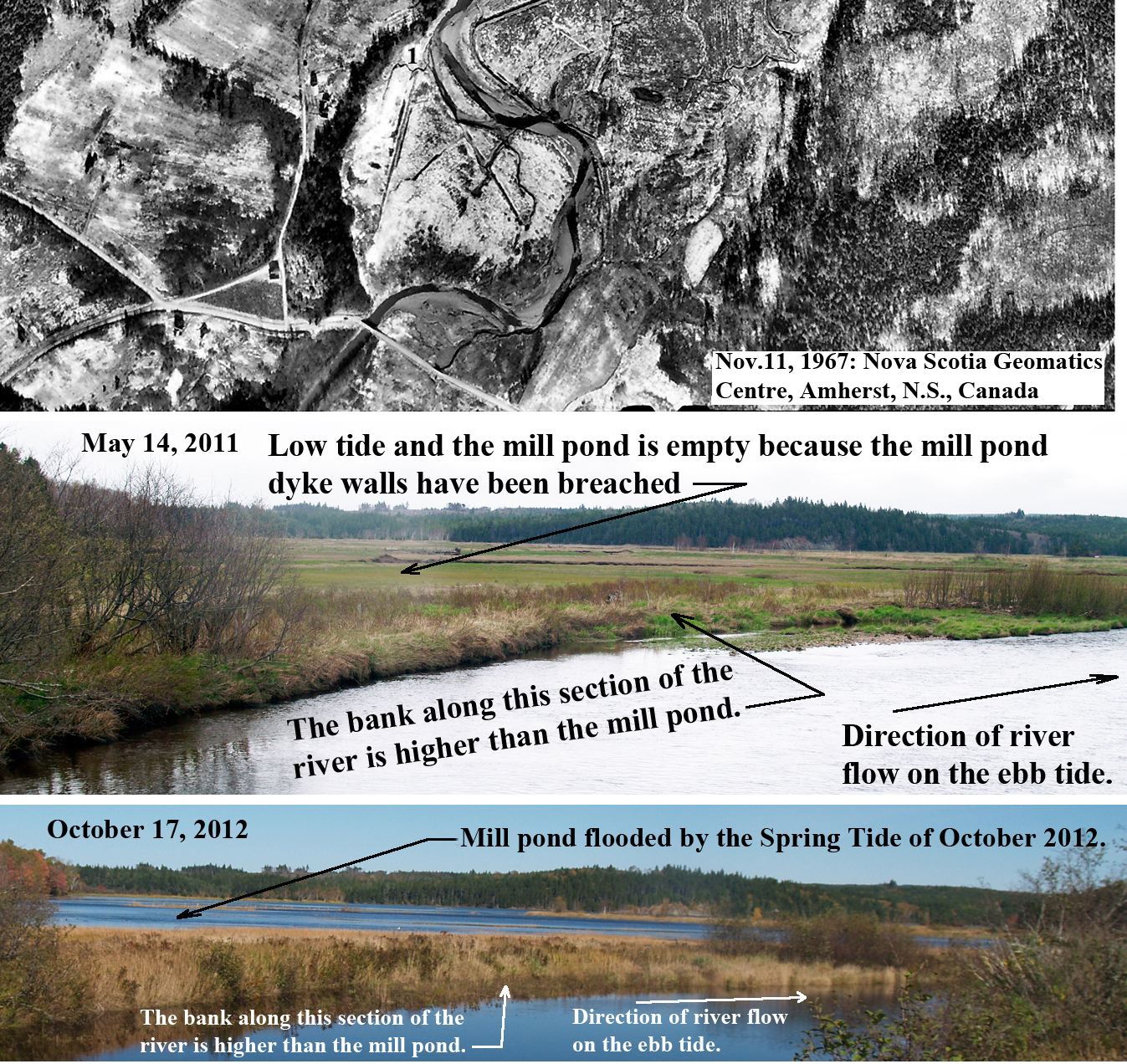
Fig.11: A ridge of upland located at the broad bottom of the mill pond forms a naturally occurring containment wall. The 1967 aerial photograph shows that this wall was much larger in the past and has been shrieking due to erosion.
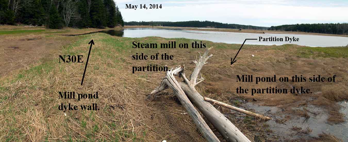
Fig.12: The modification of a section of William R. Elderkin’s mill pond. A dyke wall constructed for partitioning the original mill pond in order to create a place for Isaac Spicer’s steam mill
William R. Elderkin’s mill pond was modified to accommodate Isaac Spicer’s steam mill. This was done by building a dyke wall that partitioned the original pond as shown in Fig.13. Today most of the salt marsh on which the steam mill was built has disappeared due to erosion.
Mill Owner’s Rights and Public Rights of Free Passage on a River
The question as to why the mill pond was completely located on the surface of a salt marsh must be considered. In this jurisdiction, a mill owner had the right to construct a mill on a waterway but he/she must build in such a way that the river could be used for floating purposes. The mill rights and public rights are explained by the following quote from the document: A History of Water Power Legislation and Administration in Nova Scotia located in Department of the Interior’s Water Resources Branch records (RG 89, volume 528), Library and Archives Canada
“The placing of permanent dams across streams would naturally have the effect of preventing the free passage of fish and lumber, and thereby create a conflict with these important interests. This difficulty was soon recognized by the General Assembly and since 1786 the owners of mill dams have been required to provide adequate means for the passage of fish and lumber. It will be remembered that the use of streams for floating purposes had been declared to be a public right, but this does not mean that it was such as to override the rights of the mill owner. No attempt was made by the Legislature to interfere with erection of mill dams, but merely to require that they in turn should not interfere with the rights of others to use the streams for lawful purposes.”
The legislation defining a mill owner’s, as well as the public’s, right to free passage on a river must have played an important role in the decision to build the Elderkin mill pond on a tidal wetland. Also, the Elderkin family and other Apple River families, had been using Acadian dyking methods to form agricultural enclosures on salt marshes since the early days of the community. It is also not surprising that these same methods were used to build the mill pond enclosure. This was constructed by building sod walls in the manner of a so-called running dyke. A running dyke is defined as a dyke wall that runs from one aboiteau (tide gate) to another aboiteau. A section of a running dyke for an agricultural enclosure is marked on Fig.10.
Filling the mill pond and Floating logs
The region inside the converging dyke arms marked by black lines on Fig.13 shows the area on the salt marsh occupied by the mill pond enclosure prior to the establishment of Isaac Spicer’s steam mill. This enclosure had to hold a sufficient quantity of water to power the Elderkin waterwheel and to float the saw logs for his water mill. The partition dyke marked on Fig.13 was built when the steam mill was established and extended to the dyke arm running N14W. This partitioning created a site on one side of the partition dyke for the steam mill building and a mill pond on the other side of the partition dyke for floating saw logs.
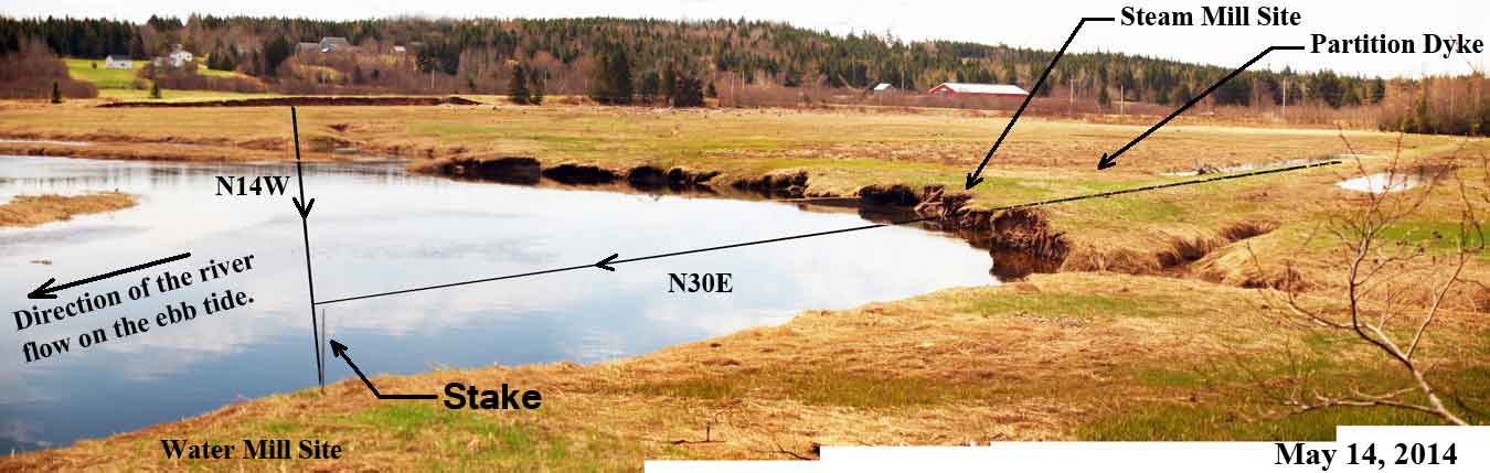
Fig.13: Erosion at the junction of the two converging dyke walled mill pond arms. Important components of the mill used to haul floating logs to the carriage and to deliver water to the waterwheel are believed to have existed in this region
The mechanism for filling the mill pond is unknown. Incoming tides only flood the salt marsh a few days a month during spring tides. However, because of sea level rise, the salt marsh would have been lower in the 1800’s. A lower marsh may have allowed gates that opened only on the flood tide to be established on one or more of the naturally occurring drainage creeks. The integers 2 and 4 on Fig.14, a 1985 aerial photograph, mark two marsh drainage creeks that pass through the converging dyke arms. Only creek 4 continently connects the former mill pond with an incoming tide; as will be shown later, creek 2 probably had an aboiteau. A comparison of Fig.13 and Fig.14 shows that a large amount of erosion has occurred at the mill sites since 1985. More dramatic changes due to erosion must have occurred after the water mill and steam mill ceased operating. It may be impossible to determine the role, if any, that the tide played in supplying water to the mill pond. A sluice, however, running from the mill pond to an up river location at a higher altitude than the mill pond on the salt marsh, would supply sufficient fresh water for keeping the pond full.
The water mill site and the region where the two dyke arms converge contain wooden structures. These timber objects, some of which connected the mill pond with the water mill, will be examined in the next section.

Fig.14: Station 1 is the water mill site and station 3 is the steam mill site. An aboiteau still exists on the drainage creek at station 5. The aboiteau that once existed on the drainage creek at station 6 has been destroyed by erosion. The running dyke in Fig. 14 ran between these two aboiteau locations.
Information gleaned from the Watermill Relics
Exposed on the Eroding River Bank
Information about the Mill’s Machinery derived from the Sawmill’s Waterwheel
The erosion of the river bank from which the relics of the water powered sawmill are emerging, began long before the author initiated his research in 2004. The changes that may have taken place prior to 2004, as well as the relics that have been lost, are unknown. The course of the river probably changed since the start of erosion and it is even possible that the watermill was initially located elsewhere, possibly on a bank at the mouth of a drainage creek that emptied into the South Branch of the Apple River; if you examine the watermill site marked “1” on Fig. 14 and the aerial photograph section of Fig. 11, you see some evidence for this. Now, it is possible to interpret photographs and measurements from what is the presently exposed mill components. Photographs can only be taken during field trips and unfortunately, objects that are uncovered between field excursions may be carried away by the tide before they can be observed and examined.
Watermill relics from the eroding river bank that have been photographed and measured will now be analyzed. These relics suggest that a complex and interesting water powered sawmill was built sometime in the late eighteenth or early nineteenth century. The complexity of the structure arises because the mill was constructed on a salt marsh and because the mill owner may have catered to the needs of shipyards. To meet shipyard requirements, the Elderkin mill would have been capable of producing large ship timbers and long planks. The structural elements used to build vessels are sawn from particularly long logs. In order to handle these longer logs, the sawmill had to have a carriage, on which one log at a time was fastened, that was as long as the longest logs to be sawed. As well, the tracks on which the carriage runs had to be twice as long to allow the carriage to move the log completely through the saw. The analysis must take these complexities into account. Also, the analysis is limited because mill components have disappeared due to erosion, the rapid decay of wood in the damp Nova Scotia environment and the market for scrap metal and antiques.
The objects available for study when the field work began in 2004 were large timbers and the remains of the shaft section of a campus arm waterwheel. During the winter of 2012-2013 the shaft was washed a short distance down river and the timbers appear to be all that remains of the building that housed the machinery for William R. Elderkin’s water powered sawmill. The timbers are located in the river bed and probably formed the supporting foundation for the building. Fig.15 shows the timber objects that had emerged from the eroding river bank by 2012; the position of the shaft in 2012 is also shown. The down river end of this structure can be seen more clearly in Fig.1

Fig.15: The possible remains of the building that housed the machinery for William R. Elderkin’s water powered sawmill. The down river end of this structure can be seen more clearly in Fig.1
Although the shaft was noticed by the author on May 14, 2011, it was actually exposed several years earlier as shown in Fig.16: a photograph taken on June 27, 2007. Fig.16 and Fig.17 also show an unidentified timber structure that was present in 2007 but it had been washed away by 2011.

Fig. 16: The exposed remains of the watermill site in 2007. The wooden object labeled “A” was not noticed in 2007. It appears, however, to be the same shaft that was flushed out of the river bank during the winter of 2010-2011 and observed for the first time on May 14, 2011. By this date another structure labeled “B” had been washed away.
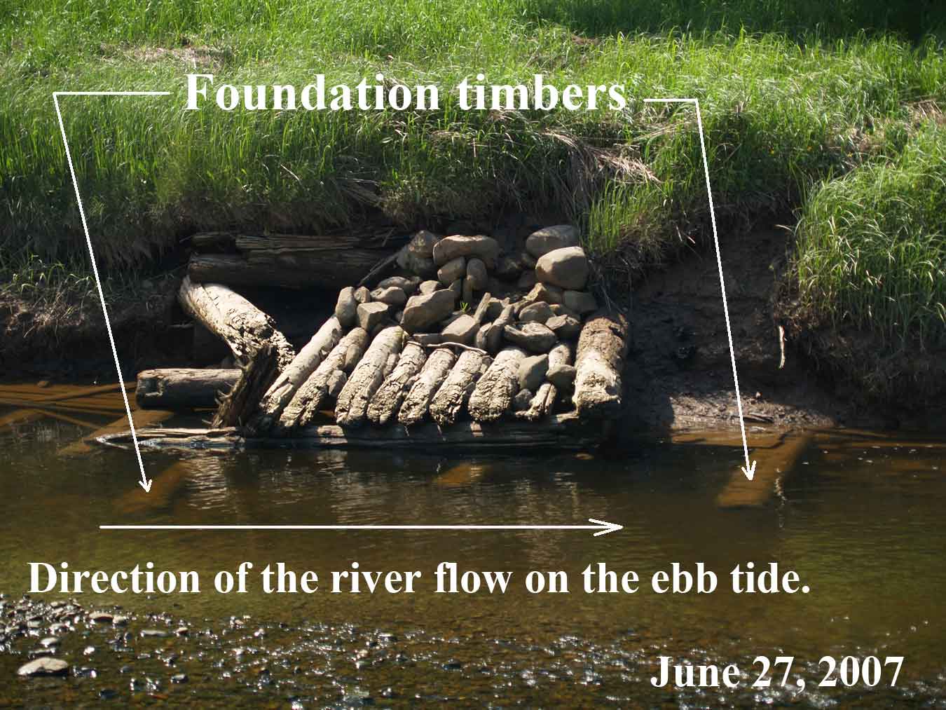
Fig.17: An unidentified structure supported by foundation timbers. Sometime between 2007 and 2011 strong currents and winter cake ice completely removed this structure.
After being washed from the river bank, the waterwheel shaft remained on the exposed foundation timbers for almost two years. During the winter of 2012-2013, cake ice and spring currents tore the pulley away and moved the shaft to a new location on the other side of the river (see Fig.18).

Fig.18: The position of the waterwheel shaft in early May, 2013. Strong currents had moved shaft as well as the pulley from the watermill site to this new location
The Pulley at the end of the Shaft
The May 2013 location of the shaft provided an insight into the “wood joinery” method used to attach the pulley to the shaft; this must have been carried out for an unknown reasons when the Elderkin mill ceased operating as a water mill. The joinery method involved cutting off the compass arms flush with the surface of the shaft. Four wide rectangular slots were cut across the grain of the shaft as shown in the top image on Fig.19. The bottom image on Fig.19 shows how these slots allowed the pulley to be joined to the shaft.
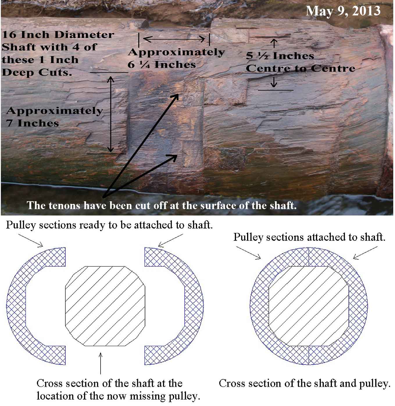
Fig. 19: Four wide rectangular slots were cut across the grain of the shaft after the compass arm tenons were cut off.
The Gudgeon at the End of the Shaft
The shaft on the Elderkin waterwheel was supported at each end by a type of bearing that partially extended into the end grain of the shaft. This was an unexpected discovery because wood is easily split by forcing a metal object into its end grain. The metal object in the end grain is called a gudgeon and this is the type described by Oliver Evans in Fig.20. As can be seen from Fig.20, bands or hoops are placed around the shaft to keep it from splitting.
Of the two types of gudgeons shown in Fig. 20, the type described by Oliver Evans probably predates the cross-tailed gudgeon. This could be an important consideration in dating a mill. The cross-tailed gudgeon is easy to spot because the front end of the cross arms are exposed.
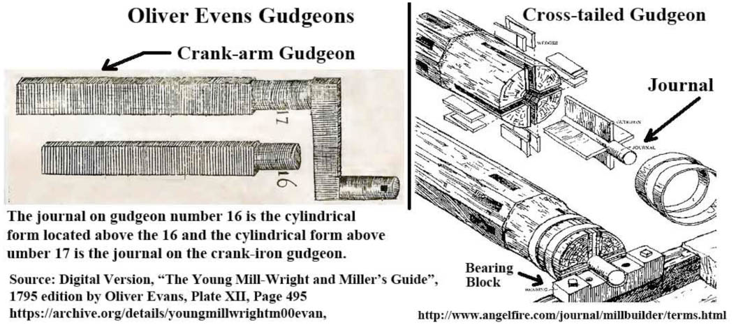
Fig. 20: The two common types of mill gudgeons.
The crank-arm gudgeon is missing from the Elderkin water mill shaft; the gudgeon at the other end is in place fortunately. Gudgeon cross arms are not exposed on the face of this shaft (see Fig. 21) but the end of a wedge can be seen between the journal and a hoop placed around the end of the shaft to keep it from splitting. The gudgeon is probably the kind described by Oliver Evans but it is uncertain why there is a wedge in the end of the shaft.
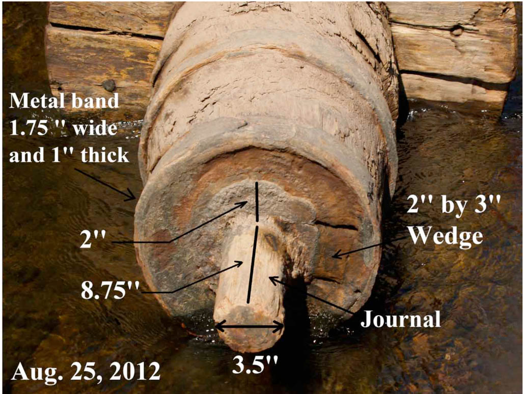
Fig 21: The journal end of the gudgeon inserted into the waterwheel shaft.
Prior to attending the TIMS 2015 Symposium in Sibiu, Romania, the wedge shown in Fig.21 was impossible to explain. The answer was provided at the symposium by David Jones. David brought a museum quality model of a mill shaft to Sibiu that had a removable Oliver Evans type journal bearing. With this model, David was able to demonstrate the clever method used to place an Evans’ gudgeon into the end of a shaft. This procedure is given in Fig.22 and was devised as a method for meeting the difficult requirement that the shaft and the gudgeon must have a common axis of rotation.
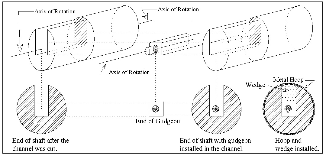
Fig. 22: Guide lines showing the depth and width of the channel that must be cut in the end of the shaft to receive the gudgeon. The depth of the channel is chosen to give both the shaft and the gudgeon a common axis of rotation.
Long Timbers not seen Previously are Uncovered by Winter Conditions
By 2014, the gravel bar shown in Fig.16 had been completely washed away and long timbers not seen previously were exposed (see Fig.23). As well, Fig.23 shows a section of the river bed in front of the timber framed crib structure that is now approximately 2 meters deep. A water pipe similar to that shown in Fig.5 can be seen along one edge of this deep hole and a platform can be seen under the newly exposed timbers.

Fig.23: Long timbers exposed during the winter of 2013-2014. Note the deep water, the water pipe and the platform under the newly exposed timbers.
Point “a” and point “b” on the top image in Fig.23 as well as letter “A” on Fig.16, indicate the position of the shaft before it was flushed from the eroding bank. This is important because the position of the waterwheel shaft in the mill can be useful for determining the location of several other mill items; the location of the mill’s saw, the location of the center of the building that houses the mill’s machinery, the length of the carriage that carries each log completely through the mill’s saw and the length of the longest log that the mill is capable of sawing. These determinations can be made because the water wheel shaft is connected to a crank arm located below and connected to a frame holding the mill’s saw. The rotation of the crank arm, caused by the rotation of the water wheel, forces the saw frame, and therefore, the saw, to move vertically up and down. The saw frame and the crank arm are placed in the center of the building to give the carriage the ability to move a log completely through the saw. Furthermore, the mill carriage must run on tracks that are twice the length of the longest logs to be sawed.
Point “a” and point “b” are marked on the center of Fig. 15; a photograph showing the possible length of the building that housed the mill machinery. Applying the above reasoning to Fig.15 suggests that the saw frame was positioned vertically above an imaginary line joining Point “a” and point “b”, possibly in the region of “S” on Fig.15. However, the length of the carriage is difficult to determine. Assuming that a log to be sawed was carried from left (point D) to right (point S) in the photograph, there is a possible 27 ft (8.2m) length of carriage track in front of the saw teeth and a possible 60ft (18.3m) after the saw! The remains of the water pipe (sluice) shown in Fig.24 indicate that the carriage probably did not extend to the left of point D. As for the length of the building that housed the saw and carriage etc., it is uncertain if it extended all the way from point D to point E, a distance of 87 ft (26.5 m).
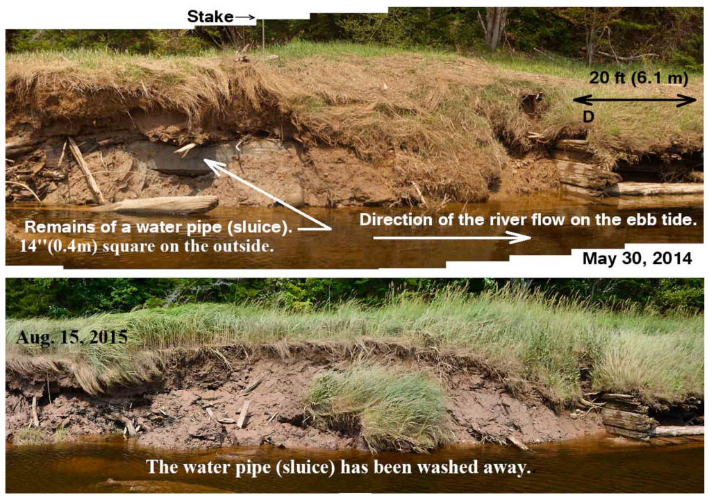
Fig.24: The junction of the mill pond dyke arms. These arms are shown in detail converging to a junction location on Figures13 and 14. The marker stake on this photograph is also on Fig.13.
The long timbers shown in Fig. 23 are difficult to interpret. They appear to form the foundation for one large building, or for two connected structures; a building to house the mill machinery and a connected structure designed for delivering water to the waterwheel as well as providing a means to haul logs from the mill pond to the location of the saw carriage. Fig. 24 shows the possible remains, now washed away because of erosion, of the water delivery system.
The Waterwheel
As indicated in Fig.25, the Elderkin watermill was driven by a low head of water that was probably no more than 5 feet (1.5m). In Nova Scotia, sawmills with a low head of water used a so-called flutter wheel. A flutter wheel using the compass arm construction would be consistent with the shaft found at the sight of the Elderkin water mill and may have been similar to the diagram on Fig.26.
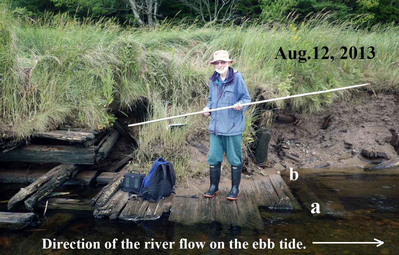
Fig.25: The author is standing adjacent to what is believed to be the location of the mill’s waterwheel. If a line were drown from point “a” to point “b” it would mark the position of the shaft before it was washed from the eroding bank. The top of the bank is barely above the author’s head indicating that the waterwheel must have been driven by a low head of water.
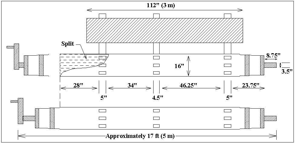
Fig. 26: The waterwheel used on the Apple River water powered sawmill may have had this form.
UPDATE Mar 20, 2021: The “may have” form I suggested above above I wrote about several years ago. I now know that to be wrong. In the summer of 2020, a crank arm and paddles had been exposed and caught on the river bank (photo below), and therefore the object is the waterwheel and has the form of a flutter wheel.
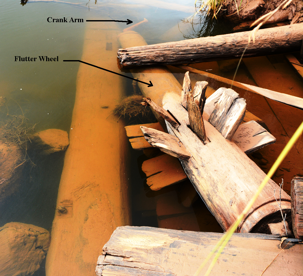 Fig 26b. Crank arm and paddles exposed on Aug 21, 2020 |

Fig 26c. Free on the stream bed, Aug 9, 2021
The Junction between the Mill Pond and the Sawmill
The aerial photographs in Figures 3, 10, 11 and 14 as well as the photographs in Figures 13 and 27 show that the mill pond had a broad region where the two dyke arms labeled N14W and N30E merged. Structures for hauling logs from the mill pond to the log carriage and for delivering water to the waterwheel must have been constructed here. However, Figures 13, 24 and 27 show that most of the bank on this section of the river has all but disappeared due to erosion. Unfortunately, in order to fully understand the workings of the mill one must have knowledge of what was built here. However, a small amount of information can be gleaned from the photographs of the few relics that were observed before they were washed away.

Fig. 27: The region where the two dyke arms labeled N14W and N30E merge. Structures for hauling logs from the mill pond to the log carriage and for delivering water to the waterwheel were constructed here.
Relics of Structures found at the Mouth of the Drainage Creek marked on Figure 27.
The brush shown on Figure 28 is similar in size and arrangement to what is found in an aboiteau (sluice plus tide gate) construction. The aerial photograph in Figures 10, 11and 14 suggest that an aboiteau may have been constructed to allow the drainage creek shown on Fig. 27 to drain, when the tide was out, fresh water from the creek area of the marsh and to block tide water when the tide is in.

Fig. 28: Brush and large timbers at the mouth of the drainage creek
The presence of timbers in Fig. 28 certainly indicates that a structure of some sort was built in the region where the two dyke arms converged.
Figure 24 shows the remains of a sluice with a square cross-section of approximately 14” (0.4m). This is a surprisingly small sluice if it was built to supply water to the waterwheel shown in Fig. 26. It is possible that the water mill had a small tub wheel for returning the carriage after a log has passed through the saw. A photograph of such a system is shown in Fig.29
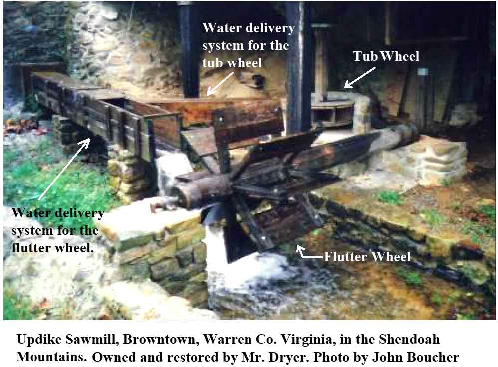
Fig.29: A sawmill with two waterwheels. When the carriage has moved a log completely through the saw, the water flowing to the flutter wheel is stopped and directed to the tub wheel. The tub wheel then moves the carriage back to the start position.
Conclusion
Field work, photographs and historical documents have been used to partially interpret the remains of a unique water powered sawmill mill located on a Bay of Fundy, Canada, salt marsh. The mill’s pond for floating logs to be sawed was an enclosure constructed on the surface of the marsh by using early dyking technology. Other relics consisted of timber framed structures and a wooden shaft flushed from the eroding bank of the tidal river flowing through this wetland. The interpretation is not complete because large sections of the mill have been lost due to erosion. Erosion will, however, uncover more remaining parts of the mill presently buried beneath the surface. A more complete interpretation may be possible if these still existing components can be examined as they emerge from the bank and before they are washed away.
References
“Amherst Daily News”: Under the heading “Cumberland News from the Chignecto Post by Ernest E. Coates. Undated copy provided by private communication.
Cumberland County Registry of deeds, May 1, 1878, page 333, Book YY
Faribault-Fletcher Apple River Sheet No.100 and 101. (1904). Retrieved May 19, 2015, from http://geoscan.nrcan.gc.ca/starweb/geoscan/servlet.starweb?path=geoscan/downloade.web&search1=R=107752
Grant, D. R. (1970). Recent Coastal Submergence of the Maritime Provinces, Canada. Canadian Journal of Earth Sciences, 7, 676.
Library and Archives Canada. (1855). Schooner Selma, Shipping Register for the Port of Parrsboro, Nova Scotia, Reel C-2451, Volume 167, page11.
Library and Archives Canada. A History of Water Power Legislation and Administration in Nova Scotia
Department of the Interior, Water Resources Branch, Report # 684, RG 89, Volume 528
Nova Scotia Archives and Record Management. Built Heritage Resource Guide, A.F. Church Co. Maps (Publication. Retrieved May 19, 2015: http://novascotia.ca/archives/virtual/builtheritage/results.asp?Search=&SearchList1=11
Parrsborough Township Registry of Deeds, May 13, 1886, page 134, book 13.
Parrsborough Township Registry of Deeds, March 20, 1888, page 290, book 14.
Robertson, B. R. (1986). Sawpower: Making Lumber in the Sawmills of Nova Scotia. Halifax: Nimbus Publishing Limited and The Nova Scotia Muse